A Kiwi couple's cruising adventures on America's Great Loop and around the coast of New Zealand

Sunday, 24 March 2013

Back in the US, back in the US, back in the US - eh!

Apologies to the Beatles (those that are left, anyway)

After a bumpy ride across the Pacific - turbulence for the whole 12 hours, which I have never experienced before, we arrived in LA, stayed a night then flew to Orlando. We caught up with Jack, Denise and Beatriz the following day before driving to Indiantown. Coming down the road to the marina we could see Loopy Kiwi, still afloat, and looking just like we left her. We drove to Stuart the next day and provisioned up before dropping the rental car back to Hertz, who gave us a lift back to Indiantown. Everything still worked fine - Pete started immediately, but Stan needed a bit of battery charging to get him going. We departed on Thursday and headed for Stuart, intending to stay at a free dock near downtown. On the way we went through Charlie and Pauline's first (and only) lock, passed 2 alligators sunning themselves on logs and a number of turtles doing the same. We also lost our transmission on the port engine twice, and after initial concern over losing a prop, or mechanical failure of the gearbox, we tracked it down to a connection fault in the electronic shift control, which was overcome by shutting the engine down and restarting it. We intended to investigate further when we reached the next marina, but the fault hasn't recurred since. We did get the opportunity to see how Loopy Kiwi performed on one engine - which was a whole lot better than I expected, but I'd rather not have to do it again.

When we arrived at  Stuart, we found the free dock was reserved for a large paddle wheeler, the adjacent slips were too small for us and the water was VERY skinny. Also the wind was blowing directly in, so we continued on 2 more miles and anchored in the lee of a nice bay called Hoggs Cove in 10-12' of water. In the evening the wind dropped and we had a very pleasant first night on the pick (hook). We were surrounded by pods of dolphins and many of them had been accompanying us once we left the fresh water of the St Lucie river.


On Friday we left the Okeechobee waterway at Hells Gate peninsular, where we were told a Manitee was in the Channel in front of us. We never saw it, which was unsurprising, considering the number of idiots in small boats tearing around at speed despite the "no wake" signs. A little further up the ICW we encountered a single barge tow (another first for C & P), followed a few miles further on by a second, larger, tow. We decided to overnight in Fort Pierce and just before the entrance we were passed very closely by a Carver MY at speed without any radio contact or attempt to slow. The vessel was called KNOT A LOT, which was about as much as the jerk knew about the colregs or courtesy. We tied up alongside the main dock in the marina and as we were finishing, a Manitee surfaced but submerged again before C & P had time to see it. Later in the day, however, 3 more swam past at various times, so we got a good look at them then. The restaurant was immediately adjacent and had a good muso playing so we partook of the fare, although the pork chops Charlie and I had were less than memorable.
 
 
Saturday we departed Ft Pierce intending to travel 20 miles to stay at Vero Beach Marina, as it was very highly recommended. However on arrival, the Inn was full so we continued on another 7 miles to an anchorage at Wabasso Bridge. Quite sheltered and next to the "no wake" zone for the bridge, we had a peaceful evening watching the state law enforcement boat pulling over fisho's, presumably checking their licences and catch. This morning we woke to another tow dragging a dredge barge with its pipes hanging out the back and doing about 4 knots. He WAS actually towing it!!
About 10 minutes later a tosspot in a Bayliner, who had gone to the same sailing school as KNOT AT ALL, came by and rocked us about. I hope he was in a real hurry because the dredge tow was still in sight and he wasn't going to get past him for quite a few miles. Maybe he came to enjoy cruising at 4 knots for a while, but I doubt it. We got underway in blustery conditions shortly after and by the time we reached the wide part of the Indian river, the wind was honking around 35kts. We called Melbourne (Florida not Australia) Marina for a slip. They had one left our size, so we grabbed it. By the time we were tied up, the wind was gusting 45-50kts, but still warm and humid. We walked up to the Historic Downtown area, which was predominantly closed, and lunched at Meg O'Malleys Irish pub, where they had bangers and mash with REAL sausages. They were so good that we asked where we could get some, and they sold us a pack of 20 precooks for $30!!!!! AT LAST......REAL sausages in the USA.
They also had a cup of soup for 18cents and a few kegs of Miller Lite beer left over from St Patrick's Day which was coloured green....
All in all a very satisfying experience and I recommend them to all. However, while we were there, the TV was broadcasting Thunderstorm and Tornado warnings for the area, so we scuttled back to the boat. As it turned out, that storm passed further north of us and dumped mainly on Orlando and Cocoa (where we were planning to be tomorrow). Shortly after our return, a pontoon boat pulled into the fuel dock with a group of youngsters clad only in (skimpy) swimwear. Although it was still warm (85F..29C in the boat) it was cooler outside and the kids were soaking wet and, although several of the guys were wringing out wet T shirts, the girls had no other clothing. Now, the Admiral is going to LOVE what I did next. I felt soooo sorry for them that I donated the last of my "Fruit of the Loom" work Tee shirts (5 for $11.95 at Walmart) to them to stay warm. You would have thought I had given them fur coats from the grateful response I got.......I will have to buy some new ones now.
Another thunderstorm has just gone by, but the wind has now dropped, so its getting warm and humid again. Here's where we are at the moment:
TTFN


Friday, 15 March 2013

Back to the future

I'm sorry to have taken so long to update the blog, but as I said in the last posting, it is quite disheartening doing so, and I have also been somewhat preoccupied over the past two months.

The Admiral is recovering well, but slowly. She had 4 trips to the hospital in the end - the first for 5 days, then straight back in for another 2 days, 2 weeks at home and back in for another 2 days, another 2 weeks at home then back in for 13 days. I think that adds up to 4 admissions and 22 days "inside". 2 trips in ambulances, Xrays, MRI's and two trips to theatre for angiograms and a stent, plus the pharmacy full of drugs that she is presently on (and they keep changing) - I shudder to think what all this would have cost us in the USA, considering her heart condition was not covered by our travel insurance while we were doing Stage 1 of the Loop!

Last month we had our "kids" over (including Shawn, who lives in Australia) plus my sister who looked after Woody, and a few friends for Christmas a dinner on the 25th  (a couple of months late). We had turkey and ham and mashed potatoes and gravy, roasted veges and cranberry sauce - all very reminiscent of our Thanksgiving day feast at Panama City. Finished it off with steamed fruit pudding with custard and cream and ice cream. Plenty of bubbles and sangria. Carolyn is going to stay with our son Adam, who lives on Great Barrier Island in the Hauraki Gulf (nowhere near the Gt Barrier Reef), while we are away shifting the boat.

We took Shawn out for a weekend in Kindred Spirit (yes - we still have her..... and she still goes) and we fished and he dived and we finished up with several meals of fish and shellfish - snapper, REAL mussels and a few scallops.


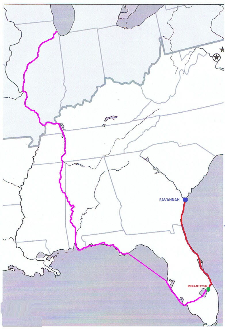
Charlie, Pauline and I leave tomorrow night for our return to the USA and delivery voyage of Loopy Kiwi to Savannah to rendezvous with the cargo ship that is bringing her home. About 2 weeks ago we got an email from the shipping Company informing us that, due to lack of cargo, the ship was going to bypass Savannah , and the next sailing was 3 weeks later! As we had already bought and paid for the airfares to and from NZ to Savannah, plus all the other travel arrangements, this threw us into a bit of a tizz - but fortunately, after several days of negotiation the freight company managed to talk the shipping company into calling at Savannah, so the schedule was reinstated (although the sailing is now 5 days later). So here's the final leg of her Great Loop voyage (in red, of course):
 
While I was updating the map of our Loop trip so far, I noticed that the map itself finishes just north of Savannah. Maybe it was trying to tell me something.....spooky eh?
 
Thanks again to our well-wishers. I hope we can catch up with some of you during the last part of our US journey, and you know you will always be welcome to visit us in New Zealand


Wednesday, 6 February 2013

Les Miserables

The return to New Zealand from Indiantown was long and arduous and included an 11 hour layover in Houston due to a broken United Airlines B787 "Dreamliner". The day after our arrival back home, Carolyn was admitted to hospital and was found to have suffered a heart attack and had to have a stent put in one of her coronary arteries. There has been a further episode which has her back in Hospital at the moment with the likelihood of another stent in another artery. While this is a common procedure these days and her prognosis is good, she will require around 6 months of careful monitoring and rehabilitation. However, even if she becomes well enough to endure the long haul flights back to the eastern USA, we would never be able to get travel insurance to cover this condition and the risk of a recurrence over the extended period of completing the Loop is too great to take. It became obvious early on that our adventure was over and the only logical alternative was to bring Loopy Kiwi back to New Zealand to cruise more familiar ground.

So....arrangements have been made for the shipping to take place from Savannah GA in mid April. I will travel back to Indiantown, along with Charlie and Pauline to assist, in mid March and we take take Loopy Kiwi the 400-odd miles to Savannah (so we get to complete nearly half the Loop). There, she will loaded onto a cradle and put on the ship, which takes a month or so to reach the Port of Tauranga, about 200 miles south of Auckland where we live. We will bring her up the coast and should be in our local marina by early June. While we are both devastated at not being able to complete our dream of cruising the waterways of the eastern USA in our retirement, we have managed to console ourselves with the thought of having our lovely boat back here in NZ. We also get to show it off to friends and family that otherwise would have never got to see her, and we could do a lot worse than cruising the coast of New Zealand instead - Woody is going to love it!!!

I had read a few blogs about the Loop that finished suddenly, usually with the boat being left somewhere while the owners went home for some reason, and I always surmised that there was a tragic story attached to the premature end of their tale. I guess this is ours, but I will continue to update the blog even though I find it quite disheartening to do so at the moment. Any reader who is contemplating doing the Loop should take heed of our circumstances and "just do it" while you still can. You just never know what is around the corner.

To all our Looper friends that have already heard our sad news and offered good wishes for Carolyn's recovery and condolences for the demise of our Loop adventure, we both thank you very much.

"I dreamed a dream in days gone by"  - Fantine (Les Miserables)

Tuesday, 1 January 2013

End of stage 1

The day after our arrival at Ft Myers, we walked down to a farmers market adjacent to the marina. On the way back we stopped in at a restaurant/bar across from the road for a drink and had lunch cause it smelt good. We finished up staying until 7.00pm, playing the owners brand new Epiphone guitar that he was given (but can't play) and chatting with the stand up comedian that works there. It turns out they were having a charity show the following night and their resident young country singer/guitarist couldn't make it (we heard him sing that day and he's real good!), so guess who got seconded to replace him - with the promise of free beer! Unfortunately that night was unseasonably cold with a howling wind and only around 35 people turned up, but it was a good night all the same.
We spent a wonderful Christmas with our good friends Jack, Denise and Beatriz from JADE and Denise's family in Orlando. We had dinner with them on Christmas eve and lunch on Christmas Day, with the usual exchanging of presents and we were honoured to feel part of their family for the occasion.

Boxing day is not a public holiday in the USA (neither is the day after new years day) and the roads were crowded on the way back from Orlando - in fact we ran into a 1 hour jam caused by a truck broken down on a bridge. We departed Ft Myers the following day and headed up the Okeechobee waterway across Florida towards the Atlantic side. Past the first lock, and after the "No Wake Manatee zone" signs had all gone, we finally came across two of them swimming downstream and managed to follow them for 15 minutes or so to satisfy Carolyn's curiosity in seeing them in the wild. The waterway is stunningly scenic compared with the Gulf ICW and had one more surprising attribute - it is relatively deep, 20 -24 ft for much of the way to Moore Haven (where we stayed overnight) and to Lake Okeechobee. The lake itself, however is quite shallow, with 6-8ft much of the way and the deepest part around 10-12ft. It also has a 50ft high dike all the way round it to prevent hurricane surges from the lake flooding the surrounding countryside.
The trip across the Okeechobee (or more correctly, up the Caloosahatchee river) gave me the opportunity to confirm something I had been suspicious of since the beginning of the trip. The speedo on the Tridata has been reading in MPH and has generally been the same numbers as showing on the chartplotter, which reads in knots - indicating that the instrument is reading 15% slow. As the sumlog (distance recorder) derives its data from the same source, it suggests that the distance travelled will also show as 15% less. Using the mile markers on the waterway, I could confirm that this is the case, so can adjust the figures to establish "real" mileages. (It also make the fuel consumption look better). So far we have travelled about 2600 NM (almost 3000 statute miles), so future trips around the New Zealand coast may not seem such a long way as they have in the past.

Another thing I was able to confirm was my growing suspicion that something was drawing off Stan's starting batteries when the engines were stopped, which caused them to go flat after an extended stay in a marina. After 3 such episodes (Aqua Yacht Harbour, Panama City and Tarpon Springs - even after replacing the batteries), I decided to switch off the start batteries at Ft Myers for the duration of our stay. When they were turned on again, Stan started perfectly after 8 days sitting idle, without charging. This would not normally show up in a standard Silverton configuration as the batteries are always being charged when connected to shore power. I suspect it may be the Electronic Diesel Control, which remains energised while the batteries are switched on and is powered by Stan's batteries It is back lit but would not have thought that the lighting alone would draw enough current to flatten 2 start batteries in a week.
Indiantown is about 10 miles down the St Lucie canal and is separated from the lake and the Atlantic by locks, so is considered a very good "Hurricane Hole" We arrived in the early afternoon and realised quickly that the plan to haul out on New Years Eve and depart to Ft Lauderdale on the 2nd January had a few flaws. The local hotel was booked out over the period and as there was no other accommodation, we decided to leave the boat in the water during our return to New Zealand and haul it out on our return to prepare for Stage 2. This not only gave us accomodation while we packed up, but is also marginally cheaper for the 3 months. The Canadian couple, Ron and Donna, whose slip we occupied when they left to another marina in Stuart, have also kindly offered to take us to Ft Lauderdale tomorrow to begin our journey home. Last night the marina put on a Barbie and a few of us (mainly Canadian snow birds) sat up to see in 2013.

Tomorrow we leave for "home", but it feels rather weird as Loopy Kiwi has now become very much our home and there is a definite sense of "unfinishedness" about leaving her at this time. Hopefully everything will go smoothly when we return to sort out our affairs in NZ and we can get back pronto to continue where we left off.

Next stop NZ (via Ft Lauderdale, Houston, Los Angeles)....see you then and
HAPPY NEW YEAR


Friday, 21 December 2012

and crab pots

As part of my last post, I was also going to mention crab pots and the part they play in the Great Loop adventure. There are literally thousands of them all along the route and at times encroach into the ICW itself, which I am sure they are not supposed to do. This is another reason continuous vigilance is necessary as they are hard to spot and any lack of attention could have you wrapping one around your propellor in quick time....been there, done that. There was one of our "almost groundings" the other day where we were in a stretch of the waterway between markers and suddenly encountered a field of buoys in only 5ft of water. Although the GPS showed we were in the ICW, I began to worry that it was in error (surely the ICW isn't that shallow and contain crab pots!!??!!) and turned towards a marker on our port side. As we approached what turned out to be a sign telling us we were in a Manatee zone - "no wake speed only" (another thing many local boaters ignore), we were also in 4.5ft of water which was shallowing rapidly. We gently reversed back the way we had come, amongst the crab pots, and continued our journey down the ICW where it soon deepened back to its usual 6-8ft. The moral  that day was "trust your GPS".

 I personally think that there should be an open shooting season on any crab pot found within the limits of the ICW. Perhaps if a few of the errant buoys were blown apart and the lines sunk, the owners would be less likely to put them in places that are a hazard to navigation. Speaking of which and considering the thousands of them out there, I have never actually seen anyone lifting up a crab pot and some of the buoys look like they haven't been out of the water for years. Who do they all belong to?? How often are they checked?? From the price of crab in restaurants and shops and the amount of it available, it would appear that the poor critters are becoming fewer and fewer and with the number of pots out there, this is hardly surprising.

They tell me it gets worse on the other side and the lobster pots up in the Chesapeake will give us nightmares. Sounds like fun.

TTFN

Thursday, 20 December 2012

Skinny Water

Being from an engineering background, I have a tendency towards caution of things mechanical. In the early days, I spent a lot of time anxiously watching the engine performance gauges to ensure that things were running OK as mechanical failure is one of my pet fears. It was certainly uppermost in my mind when we crossed the Gulf, followed by the fear of hitting something in the dark. The weather was one of my least worrisome aspects of that crossing. After a short time on the river system, I "got over that" and found my major area of concentration to be on the depth gauge.

When I was planning and researching the Great Loop, I spent a lot of time cruising it on Google Earth and visualised a series of natural waterways, charted as "Sounds" interconnected by man-made canals that, together, would make up the Intra Costal Waterway. Indeed, this is the case, but what I didn't appreciate was just how shallow these waterways would be. I visualised the "Sounds" to be like the Marlborough Sounds with steep-to cliffs rising vertically out of deep water. Where you could pull over to a shore and tie to a tree and rest comfortably for the night. The reality is that the ICW is made up of a series of shallow ponds (albeit some big ones) joined together by man-made canals that sometimes are actually dredged from the "sounds" themselves. The charts state that there are minimum water levels of 6ft at low tide, but we have seen that degrade to as little as 5ft and less in some parts of the ICW. It is very eerie being in an enclosed stretch of water where you can hardly see both sides, and being in a 200ft wide channel knowing that to venture a few yard outside the demarcation lines, you will be aground. Despite the fact that the waterway is quite straight in many of these places and you can use auto pilot (George maintains a better course than I ever can), you cannot afford to loose concentration for any time, or you will be on the putty - which makes navigating in this part of the world interesting, but stressful. Here's a pic of the iPad chart of Pine Island Sound that is typical of the ICW

The day before we left Tarpon Springs (you know..the place where Carolyn broke her arm), we got up in the morning to find the boat was not moving. That was because it was sitting on the bottom, in the mud. The trawler next to us had both his chines about 2" out of the water. We were told it was the lowest tide they had seen at the marina and it was 3 hours before anyone could go anywhere. We made sure we left late he next day and got out with plenty of water. BTW "plenty" is now anything that is deep enough for us to not hit the bottom with our props while underway. That night we stayed at an anchorage just north of Boca Ciega Bay next to an American Legion (USA equivalent to an RSA) in plenty of water. There were 2 keelboats anchored there so we felt pretty safe. The next day we departed and travelled about 40 miles to the city of Sarasota. Here we stopped at a mooring field where a multitude of mooring buoys were available on a "first come, first serve?" (served, surely) basis. It turned out however, that the field was under the control on "Marina Jack" who seemed to have a monopoly on where you can put your boat in Sarasota, and we had the option to pay a mere $23 for the privilege of hanging on the buoy to get slopped about by every local loonie that ignored the Colregs, no wake signs and common courtesy or pay $2.65 per ft to go to his marina. Ultimately we opted to do neither and continued another 1.5 miles to an anchorage shown in Skipper Bob's waterway guide. The problem was that the depths had changed at the entrance to this anchorage since the last publication and we were involved in one near grounding and a tense entry into what turned out to be a very peaceful and secure place to stay. The next day we delayed departure until we had a rising tide at 11.30 and managed to get out without seeing less than 6ft of water (WOW).

After another day involving one actual and another near grounding on the waterway (long story.....won't go into it now), I decided we would "play it safe" and stay at a marina that night. We chose the Royal Palm Marina at Englewood and turned into the marked channel off the ICW at 4.30pm, just on full tide. Most of the way down the channel to the marina, our depth sounder showed we were in 5.5 ft of water, but went as low as 5.2ft. We draw 4.3 ft, and the tides for that evening were 1.2ft. You do the math!!! To get out the next day meant we had to leave a 7.00am the next morning to have the same depth that we had on the way in, but on a falling tide, or leave in the afternoon. We opted for the afto' and left at 1.30pm seeing depths to 4.5ft on the way out meaning we had 2" of water between our props and the bottom. That night we stayed behind an island in the Pine Island Sound called Useppa island. It had a deep channel around to the back of it and plenty of water to spend a secure night (BTW "deep" was 7-9 ft). The interesting thing was this isolated patch of land in the middle of nowhere was absolutely covered in multi million dollar houses!


The next day, as we plodded our way down the ICW, we heard a call from a boat gone aground on his way in to Royal Palm Marina. This was 10.30 in the morning and on a falling tide. Despite his calling Towboat US (equivalent to AVCG), he was not going to get off there for at least 4 hours.

I watched a program on TV while we were at Tarpon Springs on the local "Florida" channel that explained how all the canals and waterways in Florida came about. Apparently, 100 years ago, most of Florida was swamp (which explains why the capital is in Tallassee in the pan handle - nobody lived much further south) Then the Federal Government decided it was a waste of land, so they commissioned the Army Corps of Engineers to build a bunch of canals to drain the swamps - which later became useful for transport. Then the developers moved in and started selling off the land as "some of the most fertile farmland in the USA". A number of them went to prison for perpetrating that myth upon an unsuspecting population. They also began digging their own canals and laying the spoil alongside as canal-type housing developments. This all fell over when the depression, then WWII came along and the developments sat around for decades unused. Then came the advent of cheap production fibreglass boats which rekindled interest in waterside property and resulted in the proliferation of canal developments with expensive housing with which Florida is riddled today.

Yesterday we left the Gulf ICW and are now on the Okeechobee waterway at Fort Myers. We are stopping here for a week and will drive up to Orlando to spend Christmas day with our good friends Jack and Denise from JADE. We will then depart for our last stretch of Stage 1 to Indiantown where Loopy Kiwi will be hauled out while we return to New Zealand to "settle our affairs" (as it were).
Sorry about the delay in posting, but I have been somewhat preoccupied over the past few weeks. In case I don't get to do another one before Christmas, everybody have a Merry Christmas and a Happy New Year (I'm sorry - "Happy Holiday" just doesn't do it for me!)


Thursday, 6 December 2012

Fine weather with the occasional tornado

Following on from the last posting, the battery tester turned up and confirmed that both Stan's start batteries were dud, but all the rest were OK. So I moved the 2 start batteries I was using for house to replace them and in turn, replaced those with 2 new deep cycle batteries, which I got from Sam's Club so they are the same as the others in house service.

We decided that continuing on would be too hard with a one armed deckhand, so I booked to stay another week at this marina. As it turned out, their rate for 2 weeks and one month are the same, so we can stay until we are ready to go, or Christmas day (whichever comes first). Carolyn is improving each day, so hopefully we will be in a position to get away when she has been back to the Orthopaedist in Clearwater in a weeks time. We will certainly need to be underway well before Christmas to get to Indiantown in time to lay the boat up prior to heading home on January 3rd.

Speaking of home, we got an email from Pauline today telling us about the tornadoes that hit near where we live. It would appear that the one that did the most damaged passed within about quarter of a mile of our house. Three people have been killed and seven injured...Auckland is not normally known for tornadoes, but this is the second one in about a year that has killed people within a few kilometres of our home. This is a map of Auckland showing where they hit. Our house is about where the marker is on the map.
and a couple of pix I lifted off google. The first looks to be taken from close to where our friends Dennis and Kathy live. Our house would be to the extreme left of the pic.
and this one appears to be taken along Hobsonville Rd, where I frequently walk with Woody
Several friends have checked out our house and it appears there has been no damage.

In the meantime, the weather here is gorgeous. Since we have been here, the temperature has been around 80F (26C) during the day and dropping to around 15 - 17 at night. They haven't had any rain here for 65 days and there is none apparent for the next week or so. I'm getting a lot of biking in since the rental car was returned on Monday, but it is all flat here so it is no real task. All of the major shops are within easy biking distance and we are very close to the commercial docks and fresh seafood supply. Last night, just to see what lived in  the river, I tried my hand at fishing and landed 3 catfish off 4 baits. They are smelly, slimy things that croak like a Gurnard. Even though they come out of seawater, I had no desire to eat them based on previous experience with catfish in restaurants on the river system - so they all got thrown back. However, they also have bony spines on their pectoral and dorsal fins that lock horizontally from their bodies when they are agitated. The last on to be returned slipped out of my hand and landed on my foot, gouging my ankle with his spine. It didn't hurt a lot, but I bled like a stuck pig for about 20 minutes. I checked on the net to see if the spines are poisonous, and apparently some are...but not this one cause I'm still here. Having said that, these 5 vultures were sitting in a tree dead opposite the boat when  I got up this morning....Hmmmmm.....

TTFN