
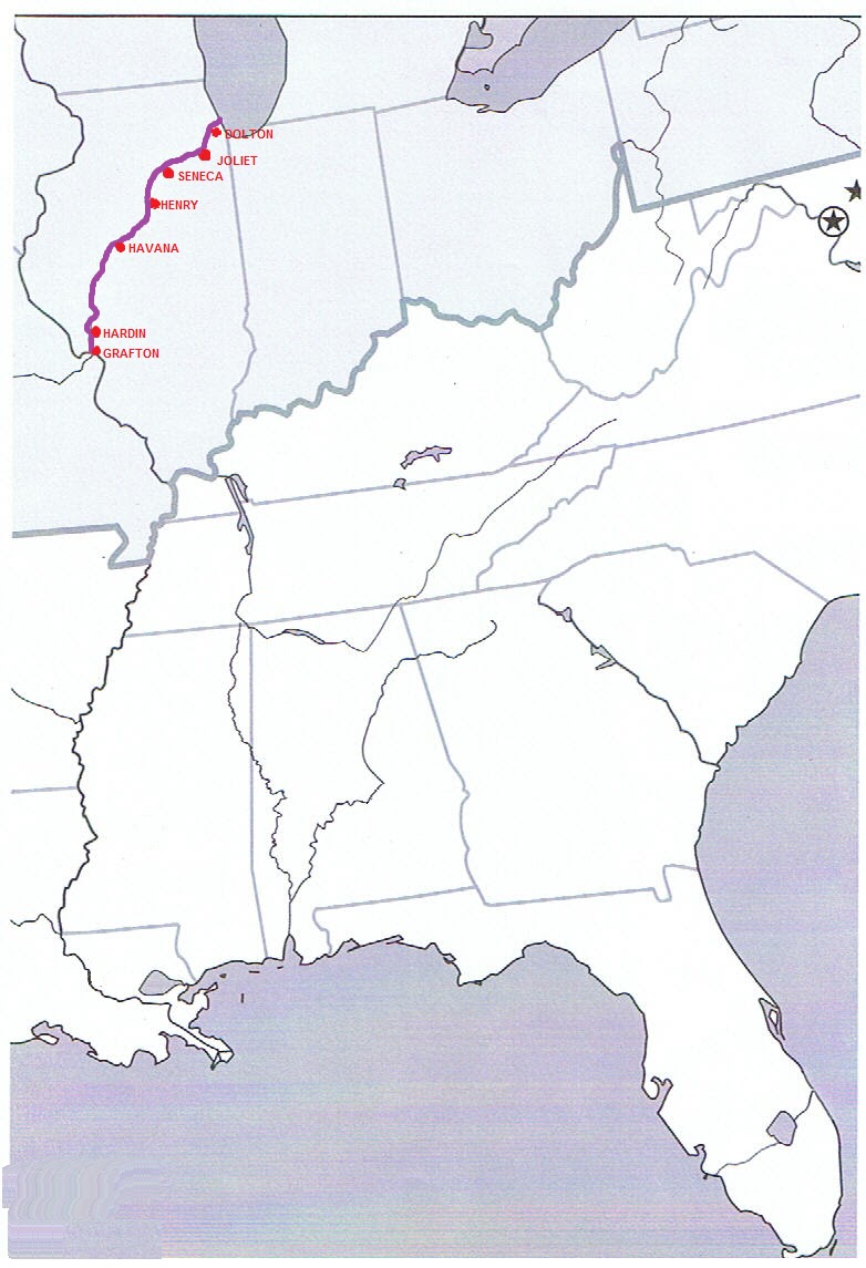
The lack of this adapter limits the availability of power at some marinas and other stops (such as Joliet, where there is free docking on their city wall, but only 30A power - and I need 50A.
Last posting we were in Henry, IL, a cute wee marina alongside a abandoned lock. The only 50A supply was along the old lock wall where the rocks were like razors. Tying up was interesting as there were no cleats and we wound up tied to trees, fence posts and anything else we could loop a rope around with plenty of wadding around them to prevent chaffing.
We had been hearing reports of low water levels restricting marinas and anchorages further downstream so we figured we needed to do some big miles to avoid these issues.The next day we planned for a 76 mile run down to a small town called Havana, where there was a marina with all we needed. We rose early and got underway with everything going well until Peoria Lake, where the map on the GPS ran out and shortly after so did the map on the iPad. So there we were....no GPS at all. Thank heavens for paper charts. We continued through the locks and reached Havana at 3.00pm only to be told that there was insufficient water to get us in. As the next marina was at Grafton, 120 miles away, we opted to anchor out behind an island that was purported to have 10-12' of water "several hundred yards past the coal plant. We gingerly went 100 yards past the coal plant in 8' of water at which point the sounder showed 2', and we were aground. We backed off and anchored beside some empty barges in 8' and had a pleasant night of solitude - although during the night several large tows went by the other side of the island.
We rose at 5.00am the next morning (well I did anyway) and got underway a daybreak, just after 6 with the intention of making Grafton 120 miles away - a 12 hour run at best. Within half an hour we ran into the first obstacle - a thick bank of fog.


Further down, some of the anchorages in the guides were very shallow and in one case, completely dry - Willow Island at mile marker 73 is now a peninsular.
At one narrow section of the river there was a tow coming towards us (a tow is bunch of barges actually pushed by a large tugboat). He was pushing 15 laden barges and was one of the larger tugs we had encountered so far. We went through the passing protocols, he told me to pass on the "one whistle" (starboard) side, but by the time we had got by the 5 barge length, there was only about 60ft between the marker and the stern of the tug and we were in only 8ft of water. As I passed the tug, a deckhand got my attention and made round, swirling motions with his hands, and when we got right past, I saw why. At the back of the tug were 2 enormous whirlpools put up by his props as he grunted up to get his tow around the bend in the river. There was no way to avoid them so it was a matter of throwing down as much power as possible to haul ourselves out. I've never been white water rafting but I imagine its something like that - only in a 19 ton, 48ft raft. I am sooooo glad that we had 920 horses to get us out of there. I can see how easy it would be to get into trouble if you didn't have the nouse or the horsepower to get you out of such a spot.
About that time as well I noticed the fuel gauge on our port tank had suddenly dropped to read just above empty, so the next 2 hours we sat on tenterhooks, waiting for the engine to stop. In the guide book it said that there was a restuarant dock at the town of Hardin where it could be possible to order in diesel so we decided to stop there and give it a go. After 10 hours of running I had had enough anyway and we tied up and I went to the restaurant to suss it out. I had noticed that there was a gas station in town so I figured that I could get some diesel there, if necessary. The restaurant owner, Mel, told me that the service used to be provided by Farm Services, but they had stopped doing it 2 years ago due to EPA regulations. He also told me that the gas station didn't sell diesel, but offered to take me up to Farm Services and get some fuel in jerry cans. The problem was he could only find 2....one of 2.5 gallons, the other 5 gallons. So over the next 2 hours we made 4 trips the 6 miles return to Farm Services and managed to get 36 gallons in Loopy Kiwi (yep - we overfilled the containers each time).
That night we ate in Mel's Riverdock Restaurant. Skipper Bob's Waterway guide describes the food as excellent. It is wrong - the food is divine! (and I'm not just saying that because he helped us out). I have been coming to the USA for 30 years and I cannot recall having better food. It was so good we went there for breakfast the next day and it was just as good. Any Looper reading this, do yourself a favour and stop for a meal at least.
Yesterday we travelled the remaining 20 miles to Grafton, where the Illinois and Mississippi rivers meet. There were a number of other Loopers here including our fellow Kiwi, Tony, and we enjoyed cocktails and a meal with them last night. They showed us how to download the maps from Navionics down to the iPad, and now we have a GPS again. I won't bother to get a new chip for the chart plotter, we will just use the iPad and paper charts. Today some of the Loopers headed off to Hoppies, 50 miles away and the last marina for 228 miles. We will follow tomorrow, which is why I'm doing this posting now, as email will be a problem for the next few days.
Till next time
No comments:
Post a Comment